This is an old revision of the document!
PHP's gd library is missing or unable to create PNG images
Projection Type
Represents a map projection.
GUI Editor
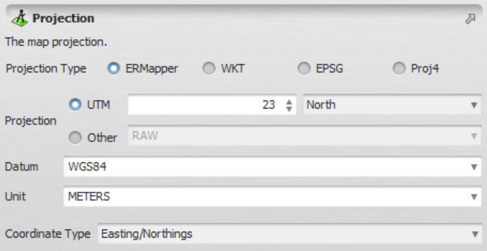
Graphical representation of the projection editor
EGO Script
A constant representing a projection in a EGO Script can be defined in two different ways:
Using ERMapper parameters
[| "COORDINATE_TYPE", "ERMAPPER_PROJECTION", "ERMAPPER_DATUM", "ERMAPPER_UNIT" |]
All parameters are case-insensitive and must be surrounded by double quotes.
Example:
[| "LATLONG", "GEODETIC", "WGS84", "METERS" ]
Using a WKT (Well-Known Text) description
[| "COORDINATE_TYPE", WKT_PROJECTION |]
The syntax used to the represent the WKT_PROJECTION can be found here.
It is worth nothing that only the COORDINATE_TYPE must be surrounded by double quotes.
Example:
[| "LATLONG",
   PROJCS["unnamed",
       GEOGCS["WGS 84",
           DATUM["WGS_1984",
               SPHEROID["WGS 84",6378137,298.257223563,
                   AUTHORITY["EPSG","7030"]],
               TOWGS84[0,0,0,0,0,0,0],
               AUTHORITY["EPSG","6326"]],
           PRIMEM["Greenwich",0,
               AUTHORITY["EPSG","8901"]],
           UNIT["degree",0.0174532925199433,
               AUTHORITY["EPSG","9108"]],
           AUTHORITY["EPSG","4326"]],
       PROJECTION["Transverse_Mercator"],
       PARAMETER["latitude_of_origin",0],
       PARAMETER["central_meridian",90],
       PARAMETER["scale_factor",0.9996],
       PARAMETER["false_easting",500000],
       PARAMETER["false_northing",-2000000],
       UNIT["METERS",1]]]
|]
A COORDINATE_TYPE is also case-insensitive and must be represented using keywords “en” (Easting/Northing), “latlong” (Latitude/Longitude) and “none”. The later can be used to automatically derive the coordinate type based on the projection parameters.