

Promoting Forest Conservation and
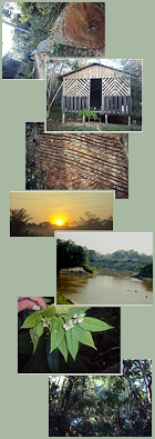
REDD aims to provide economic incentives for developing countries that reduce their carbon emissions from deforestation and forest degradation. Quantifying forest carbon stocks, historical emissions, and defining baselines for future reductions, along with their costs, are crucial to implementing REDD. In addition, building the REDD process requires that all stakeholders be involved fairly and have access to relevant information; this is the "readiness" process.The heart of southwestern Amazon is where the countries of Bolivia, Brazil and Peru meet in one of the most biologically and socially diverse regions of the world. The three contiguous political units of this region: Madre de Dios Department of Peru, Acre State of Brazil, and Pando Department of Bolivia, also known as the MAP Region, cover an area of 300,000 km2, most of which (>90%) is mature rainforests. Half of these forests are in timber production units or conservation and indigenous reserves, where some of the last remaining uncontacted indigenous tribes are trying to survive. Mega-investment projects that may well transform the region into a transportation corridor and energy source of continental importance, pose a serious threat to conservation of large expanses of the region's pristine forests. The MAP region is a crucial link in the Inter-Oceanic Highway, which connects central Brazil to Pacific ports in Peru, and is now being paved. Other road paving projects have been proposed in Bolivia, and planning is advancing for a set of major hydroelectric dams on the Madeira River and its tributaries in Bolivia and Peru. A polycentric initiative of professionals, civil society, and local governments in the MAP region has begun strengthening local and regional discussions for planning how to reduce the negative impacts of these infrastructure investments and to improve the opportunities that these will provide for regional sustainable development and environmental conservation. The overall goal of our project is to help the MAP region attain a reduction in carbon emissions from deforestation and forest degradation (REDD), through generation and organization of the requisite information, capacity-building of the key actors who are responsible for these reductions, and facilitation of viable proposals to influence international negotiations.
|